Oak Island, NC
Home MenuGovernment » Development Services
CAMA (Coastal Area Management Act)
Permitting & Information
The Coastal Area Management Act (CAMA) was introduced in the 1973 session of the North Carolina General Assembly in response to the 1972 federal Coastal Zone Management Act, which demanded solutions to mounting problems in coastal areas. The basic goal of CAMA was to provide a program for the protection, preservation, orderly development, and management of North Carolina's coastal resources.
Click the tabs below for more information:
Currently, there are three (3) types of development permits: major permits, general permits and minor permits. Some development may be authorized by exemption certificate. Single-family homes require minor permits.
- Major Permits are necessary for activities that require other state or federal permits, for projects that cover more than 20 acres or for construction covering more than 60,000 square feet. Applications for major permits are reviewed by 10 state and four federal agencies before a decision is made.
- General Permits are used for routine projects that usually pose little or no threat to the environment. General permits are issued only by DCM (Division of Coastal Management) staff.
- Minor Permits are required for projects, such as single-family houses, that don't require major permits or general permits. They are reviewed, issued by the local Oak Island CAMA officer.
CLICK HERE to download a CAMA Minor Permit Application
The Coastal Area Management Act requires permits for development in Areas of Environmental Concern (AEC).
"Development" includes activities such as dredging or filling coastal wetlands or waters, and construction of marinas, piers, docks, bulkheads, oceanfront structures and roads.
Areas of Environmental Concern are the foundation of the CRC's permitting program for coastal development. An AEC is an area of natural importance: It may be easily destroyed by erosion or flooding; or it may have environmental, social, economic or aesthetic values that make it valuable to our state.
If you're planning any sort of development -- from a sandbag structure to a bridge to a condominium -- in the coastal area, and your project is in an Area of Environmental Concern, you're probably going to need a CAMA permit. You'll also need to follow development rules specific to that AEC. You're probably in an AEC if your project is:
- in or on navigable waters within the 20 CAMA counties;
- on a marsh or wetland;
- within 75 feet of the mean high water line along an estuarine shoreline;
- near the ocean beach;
- near an inlet;
- within 30 feet of the normal high water level of areas designated as inland fishing waters by the N.C. Marine Fisheries Commission;
- near a public water supply.
Permit Exemptions
Section 103(5)(b) of the Coastal Area Management Act exempts the following activities from permitting requirements:
- road maintenance within a public right-of-way;
- utility maintenance on projects that already have CAMA permits;
- energy facilities covered by other laws or N.C. Utilities Commission rules;
- agricultural or forestry production that doesn't involve the excavation or filling of estuarine or navigable waters or coastal marshland (Note: these activities are not exempt from permitting requirements under the state's Dredge and Fill Law);
- agricultural or forestry ditches less than 6 feet wide and 4 feet deep;
- emergency maintenance and repairs when life and property are in danger;
- the construction of an accessory building usually found with an existing structure, if no filling of estuarine or navigable waters or coastal marshland is involved.
Section 103(5)(b) of the Coastal Area Management Act exempts the following activities from permitting requirements:
- Road maintenance within a public right-of-way;
- Utility maintenance on projects that already have CAMA permits;
- Energy facilities covered by other laws or N.C. Utilities Commission rules;
- Agricultural or forestry production that doesn't involve the excavation or filling of estuarine or navigable waters or coastal marshland (Note: these activities are not exempt from permitting requirements under the state's Dredge and Fill Law);
- Agricultural or forestry ditches less than 6 feet wide and 4 feet deep;
- Emergency maintenance and repairs when life and property are in danger;
- Construction of an accessory building usually found with an existing structure, if no filling of estuarine or navigable waters or coastal marshland is involved.
Rules for Beach Access Paths
(From 19th Place East to The Point)
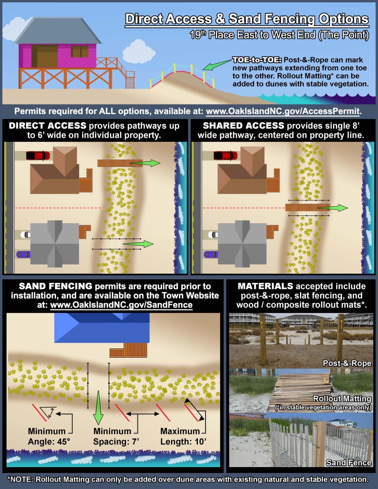
- Direct access pathway across the dune will be allowed for all properties from 19th Place East to the west end of the island (the Point)
- A direct access pathway for each property in this area will be allowed, though neighbors are strongly encouraged to share an access path
- Permit required, but there is no fee
- Every footpath across the dune must be permitted by the Town and installed before it can be used
- Walking across the dune without a properly permitted and installed footpath access will be a violation of the Town’s ordinances
Following the completion of both FEMA-funded nourishment projects, direct pathway accesses across the dune will be allowed from 19th Place East to the west end of the island (the Point). Permits for various beach nourishment projects have had different rules for pedestrian access to the beach. Since 2000 / 2001, the sections of beach included in the Wilmington Harbor Project area and the turtle project (from SE 63rd Street to 19th Place East) were required to use shared accesses placed approximately every 180 feet, in addition to the Town’s street end accesses.
For properties from 19th Place East to the western end of the island, a direct access pathway for each property will be allowed, though neighbors are strongly encouraged to share an access path on the common property line. A permit will be required to install a beach access path, but there is no fee for the permit.
A pathway can be a maximum of six feet (6') wide, as permitted by CAMA regulations, and must be identified through installation of either post-and-rope OR the optional use of non-permanent, slatted wooden or composite roll-out matting.
A pathway to be shared by abutting properties may be a maximum of eight feet (8’) wide, must be centered on the common property line, and must be identified by post-and-rope OR the optional use of non-permanent, slatted wooden or composite roll-out matting. An individual property may have only one shared access pathway; shared access pathways will not be allowed on both sides of a property. An individual property may have either one shared access or one individual access, but not both.
Town-installed footpath accesses will not be removed immediately; they can be used as the permanent footpath access for a single or shared access but a Town permit will still be required.
If using post-and-rope to define the footpath access, the following conditions must be met:
- Posts must be 4” x 4” x 6’ #2 pressure treated lumber, should not use concrete footers, and should maintain spacing of at least 7 feet between posts. The posts shall be installed with 3 feet above ground
- Posts should only be installed by hand without the use of heavy equipment
- Only rope railings – no wooden or other railing systems will be allowed. The rope shall be of high quality 1” nylon strung through holes drilled in the center of the post 6” from the top. The ends of each rope shall be heat-fused, to prevent unravelling, and secured with a double knot to prevent the ropes from being pulled through the drilled holes.
- Rope railings should be at least 3 feet above ground in order to prevent sea turtle interactions
- Paths should be shore-perpendicular only for access to the beach; should not extend more than 6 feet waterward of planted vegetation or the toe of the constructed slope, whichever is more landward; post-and-rope shall not obstruct recreation access or emergency vehicles; and shall in no case extend below the high water line
Permit Required for Individual / Shared Access
A permit is required to establish an individual or a shared access path, however, there is no charge for the permit. Information on the property and the property owners’ or authorized agent’s signature, along with a drawing of where the path is to be located, will be required for the permit. The permit application may be completed and filed by the property owner, and post-and-rope or non-permanent, slatted wooden or composite roll-out matting may be installed by the property owner.
To apply for a permit (or to ask questions about planting sea oats or installing sand fencing) contact:
Town of Oak Island, Floodplain Administrator/CAMA-LPO
Phone: 910-201-8047 • Department Contact Form
Enforcement
It’s important to protect the dunes, and the Town has several ordinances designed to do just that. A new Beach Services Unit, under the Town’s Police Department, will help make sure the rules are followed throughout the season.
Every footpath across the dune must be permitted by the Town and installed before it can be used. Walking across the dune without a properly permitted and installed footpath access will be a violation of the Town’s ordinances.
Violations of the dune protection ordinances (ARTICLE III. - Protection of Sand Dunes, Sea Turtles and Other Wildlife Habitat; Sand Management Projects) are punishable under Sec. 1-7 with fines up to $500 or 20 days in jail. Violations include, but are not limited to:
- Walking, running, playing, climbing, or other pedestrian traffic of any kind except in approved designated access areas
- Placing anything in or on sand dunes or the designated access areas
- Attaching anything to sand dune access area posts, ropes, sand fences or Town signs
- Vehicular access of any kind other than Town or emergency services vehicles in operation of official duties
- Cutting or removing dune vegetation
- Throwing refuse on the dunes or designated
- Physically altering the dunes or sand management project areas without a permit
- Development activities without a valid building or CAMA permit
- Digging in the dunes
- Mining or mechanical alteration of the dunes or access areas
REMINDER: Walking, climbing, or any other traffic in unmarked areas across the sand dunes / berms is PROHIBITED. Regulation of the dunes, berms, and most any construction in or around the public beach areas is heavily influenced by the Coastal Area Management Act (CAMA), and the North Carolina Division of Coastal Management. To accommodate the directives from these regulating authorities, the following options are available to residents and property owners:
CLICK HERE to view the Pre-Project Vegetation Line Map
NOTICE: A 2022 rule change from the State’s Coastal Resources Commission (CRC) affects oceanfront development on Oak Island:
- On July 21st, the North Carolina Rules Review Commission approved the North Carolina Coastal Resources Commission’s (CRC) proposed repeal of the Development Line and subsequent rule changes to beach front development under the Coastal Area Management Act (CAMA) program. These regulatory changes went into effect August 1st and apply to any permits applied for on or after this date.
- As a result of the Development Line removal, the CRC is reverting back to the pre-project vegetation line (previously known as the "1998 static line") for the most seaward point for ocean front development. CAMA setbacks will be measured 60 feet landward from the more restrictive of the two lines: the pre-project line, or the first line of stable and natural vegetation as it exists at the time of development. No principal structures will be allowed within the 60’ setback.
- The CRC’s new beachfront development rules do allow for the potential that the Town may develop a Beach Management Plan (previously known as a Static Line Exception). Once approved by the CRC, this plan allows for regulatory flexibility for oceanfront construction setbacks where beach communities demonstrate a local commitment to maintaining beach nourishment projects. In order for this plan to be approved, the Town is required to develop a long-term (minimum of 30 years) beach maintenance plan. The plan also must address anticipated maintenance event volume triggers and schedules, long-term sand needs, and annual monitoring protocols, as well as identification of financial resources and/or funding sources necessary to fund these long-term nourishment activities. It is anticipated that the long-term nourishment plan the Town and our engineers, Moffatt and Nichol, have been working on for the last two years will provide sufficient information for the development of the Beach Management Plan.
- It is important to note that as CAMA is a state-run program, these rule changes were proposed and approved at the state level. The Town of Oak Island recognizes the potential hardships these new rules can present for beachfront property owners and is actively working with the Division of Coastal Management (DCM) to obtain approval of a Beach Management Plan. Once the Town has a Beach Management Plan in place (i.e. approved by the CRC), setbacks would be measured from the vegetation line at the time of development, and not the more restrictive setback that would be measured from the Pre-Project Line (subject to a “no farther seaward than adjacent neighboring structure” provision). Any questions or concerns regarding these rule changes can be relayed to DCM and the area DCM Field Representative, Patrick Amico at 910-796-7425.
- The Town will have Doug Huggett and Sam Morrison from Moffatt and Nichol present at the August 16 Town Council meeting to discuss (explain) where we are and how we are currently moving forward with our application for the Town’s Beach Management Plan.
Flood Information
The Town of Oak Island wants all property owners to be aware of how they may be impacted by flooding and what they can do to protect themselves, their families and their property from flood damage.
Detailed flood insurance maps, showing special flood hazard areas, are available on the Flood Maps & Information page at OakIslandNC.gov/FLOOD or by clicking the link below.
Contact Us
For assistance with any of the information listed, please contact the Floodplain Administrator / CAMA-LPO by calling 910-201-8052, or using the Division Contact Form provided below:
Staff
-
Mendez, Margaret
Planner I
